 KRAJI - Slovenia


")
")

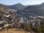 | Idrija |
 | Idrija - Old Town Centre |
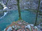 | Lake Divje jezero |
 | Idrija - Church of St. Anthony with Calvary |
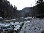
 | Path along Rake |
 | Baths Lajst |


Regional park Zgornja Idrijca
Today
1 22
Tomorrow
3 25
04.05.2026
4 25

Regional Park Zgornja Idrijca lies in the heart of Idrija's forests and extends over an area of 4230 ha. It begins in the very town of Idrija, covers the highly diversified world of the Idrijsko hribovje (Idrija hills) in the upper Idrijca River bassin and reaches to the edge of the Trnovski gozd (forest of Trnovo), Poslusanje peak. The geological structure of this region is extremely complex, comprising a mixture of pervious and impervious rocks from various geological periods. A number of rich fossil sites can also be found. Most of the park is overgrown with fir and beech trees. Despite its five hundred-year history of intensive exploitation for the needs of the mercury mine, the extensive forest area has preserved all the characteristics of a natural environment. The huge watter barriers on the Idrijca and Belca Rivers are an exceptional technical achievement dating from this period. Thriving on the steep slopes of deeply carved valleys and ravines are many rare and endagered plants, some of the most prominent being the Auricula, the endemic Carniola and Idrija Cowslips. This highly diversified forest area is a sanctuary for many wild animals. In these dense forests full of springs and mud pools one will come across the tracks of bears, red deer, roe deer, wild cats...The clear waters of the Idrijca river and tributaries around in the brook trout. Recommended visits are: Belca river valley with the Putrih and Brus water barriers, Idrijca river valley with the Idrijca water barriers, Divje jezero (Wild Lake) – a museum in nature, path along the rakes, Idrija Kamst (water wheel).
Photos
")


Data
Municipality: IDRIJA (11757 population)
Settlements in the municipality:
Idrija (5839 population), Spodnja Idrija (1414), Godovič (725), Črni Vrh (692), Zadlog (283),
Spodnja Kanomlja (250), Vojsko (238), Srednja Kanomlja (155), Predgriže (152), Dole (139), Čekovnik (134), Gorenja Kanomlja (134), Idrijske Krnice (133), Zavratec (131), Jelični Vrh (121), Gorenji Vrsnik (119), Gore (117), Lome (110), Ledine (93), Idrijski Log (83), Govejk (82), Idrijska Bela (71), Ledinske Krnice (70), Razpotje (69), Masore (65), Mrzli Vrh (55), Spodnji Vrsnik (46), Idršek (38), Pečnik (34), Korita (26), Ledinsko Razpotje (26), Mrzli Log (24), Potok (24), Žirovnica (23), Strmec (22), Rejcov Grič (13), Kanji Dol (6), Javornik (1)


