 KRAJI - Slovenia


 | Dovzan Gorge |
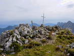 | Kosutica (Baba) |
 | Planina Korosica Pasture |
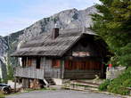 | Koca na Ljubelju Mountain Hut |
 | Tominec Waterfall |
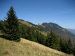 | Kriska Gora and Tolsti Vrh |
 | Kofce - Dom na Kofcah Mountain Hut |


| Dovzan Gorge |
| Kosutica (Baba) |
| Planina Korosica Pasture |
| Koca na Ljubelju Mountain Hut |
| Tominec Waterfall |
| Kriska Gora and Tolsti Vrh |
| Kofce - Dom na Kofcah Mountain Hut |
Photo: 265-0
Photo: 265-1
Photo: 265-2
Photo: 265-3
Photo: 265-4
Photo: 265-5
Photo: 265-6
Photo: 265-7
Photo: 265-8
Photo: 265-9
Photo: 265-10
Photo: 265-11
Photo: 265-12
Photo: 265-13
Photo: 265-14
Photo: 265-15
Photo: 265-16
 Camps around
 Waterfalls around
Distances in brackets are approximate air distances. Street distances can be much longer.
Municipality: TRŽIČ (14766 population)
Settlements in the municipality:
Tržič (3617 population), Bistrica pri Tržiču (2718), Pristava (897), Križe (887), Podljubelj (875),
Kovor (796), Ročevnica (577), Žiganja vas (492), Sebenje (424), Zvirče (407), Loka (363), Brezje pri Tržiču (359), Lom pod Storžičem (345), Senično (298), Retnje (273), Leše (210), Slap (183), Grahovše (121), Jelendol (120), Visoče (88), Potarje (82), Čadovlje pri Tržiču (78), Paloviče (73), Breg ob Bistrici (71), Zgornje Vetrno (69), Dolina (67), Spodnje Vetrno (59), Hudo (51), Hudi Graben (42), Brdo (33), Gozd (30), Vadiče (20), Popovo (19), Novake (17), Hušica (5)


 Hill")


