 KRAJI - Slovenia


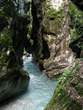 | Tolmin Gorge |
 | Kozlov rob Castle |
 | Javorca-Memorial Church of the Holy Spirit |
 | Most na Soci - Lake |
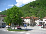 | Most na Soci - Old Town Centre |
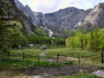 | The Tolminka River Valley - Planina pod Osojnico Pasture |
 | The Tolminka River Valley - Kurukula |


| Tolmin Gorge |
| Kozlov rob Castle |
| Javorca-Memorial Church of the Holy Spirit |
| Most na Soci - Lake |
| Most na Soci - Old Town Centre |
| The Tolminka River Valley - Planina pod Osojnico Pasture |
| The Tolminka River Valley - Kurukula |
Photo: 4100008-0
Photo: 4100008-1
Photo: 4100008-2
Photo: 4100008-3
Photo: 4100008-4
Photo: 4100008-5
Photo: 4100008-6
Photo: 4100008-7
Photo: 4100008-8
Photo: 4100008-9
Photo: 4100008-10
Photo: 4100008-11
Municipality: TOLMIN (11147 population)
Settlements in the municipality:
Tolmin (3367 population), Podbrdo (605), Volče (577), Poljubinj (436), Most na Soči (414),
Zatolmin (341), Idrija pri Bači (300), Modrej (292), Dolenja Trebuša (275), Volarje (240), Slap ob Idrijci (236), Kamno (231), Kneža (192), Čiginj (184), Ponikve (179), Žabče (160), Pečine (149), Dolje (143), Ljubinj (139), Koritnica (133), Grahovo ob Bači (125), Prapetno Brdo (124), Petrovo Brdo (122), Bača pri Modreju (121), Prapetno (116), Gorenja Trebuša (114), Modrejce (108), Postaja (107), Gabrje (101), Šentviška Gora (100), Podmelec (96), Kanalski Lom (84), Stopnik (82), Hudajužna (80), Tolminski Lom (78), Kozaršče (78), Sela pri Volčah (68), Klavže (62), Logaršče (60), Roče (59), Čadrg (49), Gorenji Log (45), Temljine (43), Rut (42), Stržišče (40), Polje (38), Zadlaz-Žabče (38), Drobočnik (30), Zakraj (28), Kuk (25), Zadlaz-Čadrg (25), Selišče (22), Daber (22), Kozmerice (20), Grant (19), Obloke (19), Bukovski Vrh (19), Trtnik (18), Bača pri Podbrdu (16), Dolgi Laz (14), Volčanski Ruti (13), Gorski Vrh (13), Porezen (11), Loje (11), Znojile (11), Selce (9), Sela nad Podmelcem (7), Grudnica (7), Tolminske Ravne (6), Kneške Ravne (5), Kal (4), Lisec (0)


