Source: Public information of Slovenia,
The Surveying and Mapping Authority of the Republic of Slovenia,
State map in measure 1 : 1.000.000, 1995
www.gu.gov.si
Recommended
Mangart is 2679 meters high mountain in Julian Alps. It is the fourth highest mountain in Slovenia. It lies on the border with Italy, so it attracts many mountaineers from both countries. We can come to Mangart Saddle from different directions: from direction Lake Predil (Trieste), from direction Trenta (Vrsic) or from direction Bovec. Branch for the road to Mangart Saddle is in the nearness of the new viaduct, which is situated on the way between border crossing Predel and Log pod Mangartom. The old military road drives us to Mangart Saddle, which lies 2055 meters above sea level and it is a starting point for hiking to Mangart. The road is steep, winding and in some parts little exposed. We drive through several tunnels. Driving in this road is a wonderful experience. On the way we can stop on resting places. It was built in the year 1983. We have to pay to use the road. During driving we have magnificent views to near and distant neighbourhood. The road is an attractive destination for cyclists and motorcyclists. It is the most beautiful mountain road in Slovenia. On the way to Mangart Saddle we can see sheep in the summer time and it becomes the paradise for lovers of sledding in the winter time.
Tolmin is the central point of the Tolmin landscape. It is situated on the balcony between rivers Tolminka and Soca. The city was between first world war, when in the nearness were taking place Soca fronts, very much demolished. In this place are the most remarkable river beds of Tolminka and Zadlascica. Tolmin river beds are the most southern entrance point to Triglav National Park, which is the only Slovenian national park. The road goes from Tolmin and one kilometre to Zatolmin. Tolmin gorge is the most important natural remarkableness. Tourist paths were built from the years 1953 to 1958. They go along Tolminka to the thermal spring and by Zadlascica to Bear’s Head. The main keeper of the road is the Tourist association Tolmin. On the entrance point visitors can buy admission ticket, receive the map of the road and all other important information. The circular trail goes to the confluence Zadlascica and Tolminka, from there to Bear’s Head, by the road Zatolmin – Cadrg to the entrance into Dante’s or Zadlaska Cave. The cave is named by the village Zadlaz. The other name got by the poet Dante Alighieri who perhaps in the beginning of the 14th century visited the cave and in this environment found the inspiration for The Hell in his poem Divine comedy. The Bear's Head is called the natural bridge, the large rock, which had over the centuries wedged between the walls of the canyon Zadlascica. You can return by the road and go across the Devil's Bridge, which was built in the year 1907. At the beginning was wooden, but later was exchanged with iron construction. From this place is a beautiful view to the Tolmin gorge, which was through the centuries shaped by the river Tolminka.
Other
Ajdovscina is the economic, cultural and industrial center of the Vipava Valley. It is located at the confluence of the Hubelj and Lokavscek streams and lies at the steep edge of the Trnovo forest. Ajdovscina has a rich and rich historical past. From Roman times the walls with fourteen Castro towers have been preserved. On the ground floor of the new market building and on the small square we can see the old Roman spas. The center of the old town is Lavric Square. Nearby is the Church of Saint John the Baptist, where one of the most famous and oldest depictions of the Way of the Cross in Slovenia, which is the work of the local Anton Cebe, is located. Anton Cebej was a popular Baroque painter who also left a mark on the church with altar paintings and ceiling murals. Behind the church are the Police Sports Center and the school district. The cultural heritage of Ajdovscina is also enriched by the artistic legacy of Veno Pilon, which can be viewed in the Pilon Gallery. The museum at the old mill houses approximately 1,200 fossils of Slovenia from the Stanislav Bacar collection. The museum presents the settlement of the city from prehistory to the early Middle Ages and a chronological survey of the fortifications. Near the center of Ajdovscina is the Aeroclub Josip Krizaj Ajdovscina Sports Airport, which offers a flight school, sports and business flights and more.
The Lookout Tower is located on the hill Mejnik above the village Gonjace. It is a central point in Goriska brda and the belvedere which in nice weather offers wonderful views to Goriska brda, Furlanija, Carnian and Julian Alps, Trnovo forest, Dolomite, Karst, Trieste bay and Vipava Valley. The Lookout Tower is 23 meters high, has 144 steps and was built in 1961. The plans did the architect Marko Slajmer. Beside the tower is a memorial, which is dedicated to victims of World War II on the right bank of the Soca River. An interesting monument is work of the academical sculptor and painter Janez Boljka. The engraved verses are written by the writer France Bevk.
Castle Gewerkenegg is located on a small hill in the old town centre of Idrija. The renaissance castle was built in the 16th century for the mine management and the storage of mercury. Castle Gewerkenegg was also a centre of trade with mercury in Idrija. The castle was through the centuries rearranged and upgraded. Courtyard facades were painted in the other half of the 18th century with frescoes, which are now restored and reconstructed. Today is in the castle seat of the Municipal Museum Idrija, which was proclaimed for the best European museum of engineering and industrial heritage in the year 1997. The museum was established in the year 1953. In its care are cultural, historical monuments, technical monuments, natural remarkablenesses and preserved buildings from the Second World War. In the museum they have the permanent exhibition named Five centuries of the mercury mine and the town of Idrija. Photographs of Idrija, exhibited documents, maps and original objects illustrate mining history, the development of floating timber and forestry. In the geological collection are presented minerals, mercury ores, rocks and fossils. In the castle are held many cultural events in the summer time, which attract many domestic and foreign visitors.
The most beautiful World War I monument is a wooden shrine that rises high above the Tolminka riverbed – the memorial church of the Holy Spirit in Javorca. The church in the walley of Polog was built by Austrian soldiers in 1916, to the design of the Austrian architect Remgius Geyling.
The outside of the church is decorated with stylised coats-of-arms of all the monarchies and lands of Austria-Hungary. The interior is classic art nouveau, adorned with colourful decorations. The idea of a memorial church is communicated through engraved oak plaques bearing the names of all the Austro-Hungarian soldiers who lost their lives on the hills of Vodil vrh, Mrzli vrh, Rdeči rob and Sleme.
Owing to its predominantly wooden construction, prone to rapid decay, and severe weather conditions, the church has undergone several renovations, the most recent one being in 2005. The church in Javorca was proclaimed a historical monument with the 1990 Order declaring natural and historical monuments and natural attractions in the Municipality of Tolmin.
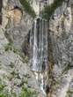
The Boka Waterfall is situated in the nearness of Bovec, in the direction to Kobarid. If you arrive from Bovec, there is the parking place in the left side of the road. The Boka Waterfall is already seen from the road, when you drive over the bridge. If you go from the parking place to the footpath and you do not cross the bridge over the Boka River, you will after about one hour and half come to the nearness of the source of the Boka River. In other way, you can also go to the the vista point, from there is a wonderful view to the Boka Waterfall. In this case you have to cross the bridge over the Boka River and right away on the other side of the bridge you go over the marked way to the vista point. In the lower part is going the settled footpath mostly in the wood. During the walk you can in some parts already see the waterfall, which is closer to you with every step. So you can decide by yourself, regarding your tiredness and available time, how close to the waterfall you will go. In the upper part is the trail going near the steep edge, so you have to be very careful, that you do not go too much close to the edge. For moderate slope from the parking place to the vista point you will need about 30 minutes. The Boka Waterfall belongs to the most wonderful and most fluid waterfalls in Slovenia. Its volume varies depending on the precipitation and on the season. The most water is in the late spring. The waterfall falls freely from the 106 metres and immediately after that another 30 metres in an incline. So we get the highest waterfall in Slovenia (144 metres). It is 18 metres wide.
The Kozjak Waterfall is one of the greatest remarkableness in Kobarid region. It is part of The Kobarid historical trail, which also includes the Kobarid museum, The Italian Charnel House, Tonocov grad Hill, Soca Gorge and other. Kozjak Waterfall or also Veliki Kozjak is one the highest waterfalls in the brook Kozjak. It is 15 metres high. The brook goes through many water channels. It falls in six waterfalls, of which only the last two are accessible to visitors. You can not go to others, because there are not available the settled paths. The brook flows at Kobarid into the river Soca. The Kozjak Waterfall is the easiest accessible from the Kobarid – Dreznica road. There is few metres after the crossing by the Napoleon bridge to Dreznica the branch for the Kozjak Waterfall. Here is also the bigger parking place. The tables will show you the way after the settled path over the meadows and through the wood. At the end of the way the footpath will lead you over the wooden bridge, which is from the year 1895. From that bridge you can see the smallest waterfall, Mali Kozjak. It is about 8 metres high. From there to the Kozjak Waterfall is about 5 minutes of walking. At the end of the trail you will cross the wooden footbridge and then you will arrive to galleries. The marvellous waterfall is hiding in the chamber, surrounded with the steepy rocky walls and under it is the pool, which is in wonderful blue and green colour. White column of the water is in the contrast with the dusky atmosphere of the chamber and creates the interesting contrast, which is mutual interacted.
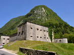
Kluze Fortress is situated near Bovec. It belongs to the most powerful and most interesting strongholds. It is lying above the deep gorge of the Koritnica River, in its most narrow part. Before the Kluze Fortress is a small park, where are also the information tables. The primary Venetian fortress was erected in the second part of the 15th century for defence before the Turks. The Venetians were banished away in the year 1509 and the Kluze fortress came into the Austrian possession. It was strengthen at the expense of the Carinthia provincial States and it became the seat of the district. In the second part of the 17th century the governor general of a province Georg Filip von Gera took care for the necessary improvement and completed it. The Kluze Fortress played the important role in the French wars. It was burnt down and destroyed in the year 1797. In the years from the 1881 to 1882 the remains were pulled down and they built the new fortress in the same place. Between the First World War was here the seat of the Austro – Hungarian garrision close behind the front line. After the Second World War it lost its rule and was left to the time. Between the years 1987 and 1991 they protected the roof construction and put in order the surroundings. Inside of the fortress is presented the history of the fortress and its surroundings, the smaller tourist office, wedding hall and local painting gallery. They regularly perform the games of soldiers, which are dressed in uniforms and with the equipment from the period of the First World War. Before the fortress in the direction of Bovec you can see The Castle Well from the year 1670, which is cut in the rocks. In the well was flowing the rainwater. Before that they carried the water from Koritnica River.
 KRAJI - Slovenia
 PohorjeLuxury Apartments Bolf